Seekseekqua on the Line of Climate Change
The case for readopting Indigenous fire management practices.
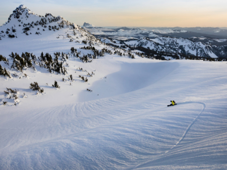
Soft hues at sundown on Seekseekqua. Josh Dirksen makes his way back to camp on Mount Jefferson, Oregon.
All photos by Tyler Roemer
Each step felt more strained as we neared a ridge and the first views of Seekseekqua. “The reservation is just on the other side of this ridge,” I yelled to Josh Dirksen and Forrest Shearer. “If we camp up here, we’ll be in good shape.”
We were traveling on skis and splitboards and would try to summit this Central Oregon volcano officially known as Mount Jefferson in the morning. For now, we followed the contours of a creek that marked the boundary between US Forest Service land and the Warm Springs Reservation. We didn’t have permission to travel on the reservation, so we stayed on the opposite side of the creek, ascending a drainage that was formed by a lava flow at the end of the last ice age over 15,000 years ago.
A deep April snowpack concealed sharp, porous volcanic rock beneath our skis and snowboards. From this white expanse rose fire-sculpted totems—pine trees blackened by fire. It looked like topographical reliefs had been laser-carved into their core with the tree rings as elevation lines. This flow was the southward boundary of the recent Lionshead Fire, which burned over 200,000 acres in August of 2020. Tyler Roemer paused to take a photo, then we continued up Seekseekqua’s southern ridge, ascending the dividing line of the east and west sides of the Cascade Range.
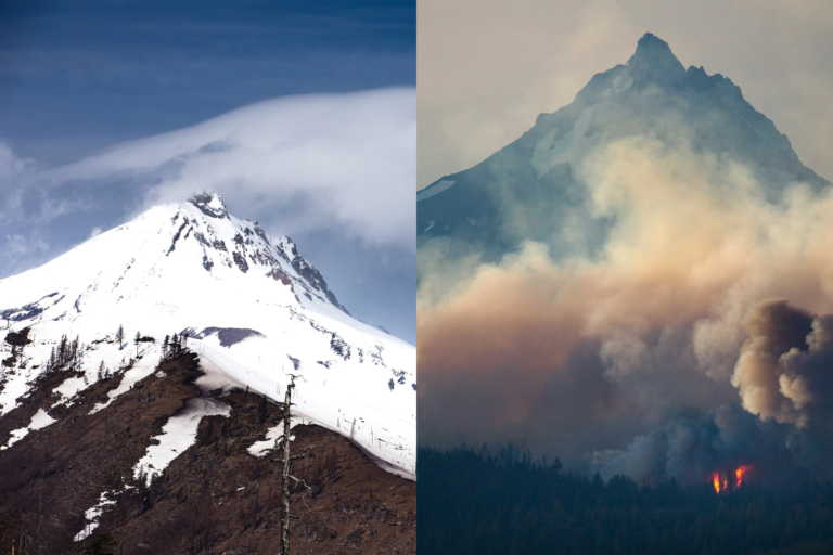
Left: Lewis and Clark gave the mountain called Seekseekqua the moniker “Mount Jefferson” in 1806 after then-President Thomas Jefferson. Here, it shows the scars from massive wildfires in 2020.
Right: The Green Ridge Fire rages below Seekseekqua on August 19, 2020. It was sparked by lightning earlier that month northwest of Sisters, Oregon.
The Cascade Range, in which Seekseekqua resides, stretches from southern British Columbia to Northern California. The prevailing westerly winds bring Pacific storm systems that drop large amounts of rain and snow on its western slopes. This means temperate rain forests down low and year-round snowpack up high, with a rain shadow creating dry, high-desert forests on the eastern flanks. Yet, the fires in 2020 largely ignored climactic boundaries, jumping to the wetter side of the range with unprecedented fervor.
The 2020 wildfire season was one of the most destructive on record in Oregon, resulting in 11 deaths, over 1 million acres burned and thousands of homes lost in the state. The Lionshead Fire was sparked by lightning on August 16, 2020, on the Warm Springs Reservation side of the drainage we were ascending. On September 7, a historic windstorm with windspeeds clocking up to 75 mph led to the explosive spread of multiple fires across Oregon, including the Lionshead. Existing fires grew by almost 3 acres per second. Lionshead combined with two other large fires to become the Santiam Fire. It destroyed the majority of a forest the Confederated Tribes of Warm Springs had maintained to generate revenue as a source of carbon-emission-offset sequestration. In the days following, the fire obliterated two towns: Detroit and Gates, on the wetter western slopes of the Cascades.
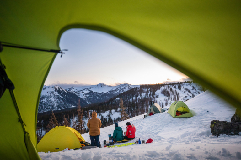
With their camp strategically placed below the ridge to minimize wind, Len Necefer, Forrest Shearer and Dirksen take in the sunset over the Cascades.
Wind is common in Oregon’s high country, and we slept fitfully under constant gusts until the first rays of morning light. The snow beneath our camp had frozen overnight. Seekseekqua sat before us glowing orange. Thousands of burnt trees sat like gravestones where the Warm Springs carbon-sequestration project once thrived. We packed up and began to climb.
Just after high noon we reached tree line at a saddle between the summit of Seekseekqua and a smaller sub-peak. We had spent most of our morning ascending a ridge and skirting the invisible line between the wilderness and the reservation. A cloudless sky and warm temperatures began melting the eastward-facing rime ice that coated many of the trees, causing them to collapse sporadically and loudly. To the west was green and lush—to the east was brown flatlands. The contrast between the two was a reminder of how ecologically significant this range is to this region.
Although Seekseekqua is currently split by the Warm Springs Reservation and US Forest Service wilderness lands, that wasn’t always the case. The arrival of white settlers and the forcible displacement of Native peoples brought the effective deletion of fire from the forest. Fire was once a cornerstone of Indigenous land management here, with local tribes using controlled burns to stabilize and renew the landscape. Settlers and the generations that followed prioritized timber sales on these lands and suppressed fire to protect this revenue stream. However, by suppressing fire, unburned fuel accumulated in the forests, increasing the likelihood that larger-scale fires would take place.
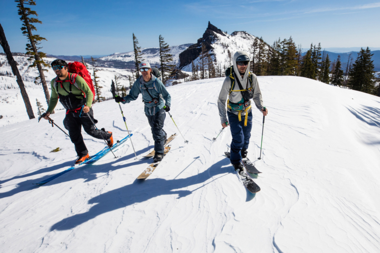
Necefer, Shearer and Dirksen ascend Seekseekqua under spring sunshine. The mountain is known by skiers for its long approach and sees relatively few visitors compared to other nearby volcanos.
On the eastern edge of this ridge, the Confederated Tribes of Warm Springs has attempted to maintain active fire management through traditional practices. In 2015, the tribe set aside 24,000 acres of forest lands for a carbon-sequestration project known as ACR260, which brought in millions of dollars each year from a carbon-emission-offset program managed by the California Air Resources Board. However, the Lionshead Fire destroyed over 60 percent of the ACR260 project in addition to the 81,000 acres that burned elsewhere on the reservation. In total, nearly half the fire’s impact was felt on the Warm Springs Reservation. In addition to the lost revenue, the fire meant less funding for the tribe to implement forest thinning and ecosystem restoration on their lands, which could help prevent future large-scale fires.
Firefighter, reclamation expert and backcountry skier Casey Tane spent a lot of time in the forest near Seekseekqua after the Lionshead Fire. Casey describes the origins of wildfire as a “fire triangle” composed of three legs that contribute to the ignition, behavior and growth of wildfires. The first leg is fuel conditions, which includes factors such as low moisture content of plants or trees, how much of this fuel has accumulated on the ground and how this fuel is arranged in the forest. The second leg is weather conditions, such as humidity, wind and temperatures. The third leg is an ignition source—lightning, humans or power lines, to name a few. In recent times, fuel conditions and weather have fostered increased fire activity. Millions of acres have not seen controlled fire for centuries, so fuel loads have increased. Warming temperatures have caused fuels to dry further. In the case of the Lionshead Fire, high fuel loads combined with high temperatures and high winds created extreme rates of spread, a long residence of the fire in the landscape and a significant mark left on the area for decades to come.
In the Lionshead aftermath, Casey described the massive stump holes, the burning of resistant fuels like nurse logs (fallen and decaying trees that provide habitat for seedlings) and the stilted roots of trees like Douglas firs as notable evidence of stand-replacing fires. These types of fires kill all or most of the living overstory trees in a forest and are usually rare on the western slopes of the Cascades. He explained that these types and scales of fires are likely to become more common in northern latitudes in the coming decades due to the two “legs” of the fire triangle shifting: the accumulation of fuel in forests without prescribed burnings and climate change driving hotter, drier weather conditions that foster greater fire growth.

Sunset on Seekseekqua. With rolling foothills leading to a summit elevation of 10,495 feet, it’s the second-highest mountain in Oregon.
Around the 12th hour of our summit day, we began descending into dark valleys under the blue of twilight. We were still a couple hours from our camp on the ridge. I tried to keep pace with Josh through quickly hardening snow. I stopped for a moment and caught a glimpse of the sunset to the west. Somewhere beneath that orange glow lay the remains of communities destroyed by the 2020 Santiam fires.
The pain of these fires is still real today for those who lost their homes. Many folks, even a year later, are still living in trailers and hotels. Many buildings have yet to be cleared of debris. The scale of this devastation and the impacts on these communities could lead to a shift in norms surrounding active fire management, such as the reintroduction of prescribed burns to reduce the chances of large-scale fires. However, the inertia of historical policies of complete fire suppression has made moving away from suppression a significant challenge.
In recent decades, there has been a much more critical look at the messaging from Smokey Bear—that all fires are bad and preventable. Much of Casey’s work for the Forest Service lately has trended toward reintroducing controlled fire into landscapes, which represents a significant shift in management of national forests. Prescribed burns during colder and wetter times of year, when fires are far less likely to spin out of control, can mitigate the growth of future wildfires because it reduces fuel sources under more manageable conditions. However, it will take a significant amount of work to build public support for controlled burns. For better or for worse, the public perception of fire is shifting due to the 2020 fire season that ignored any concept of a wet/dry divide in the Cascades.
If we learned anything from the Lionshead Fire, it’s that the western flanks are not protected from devastating fires, and the experiences of people from Warm Springs to Mill City can attest to that. Perhaps we can learn from their experience and adopt practices that encourage controlled burns to mitigate the future possibility of devastating fires.
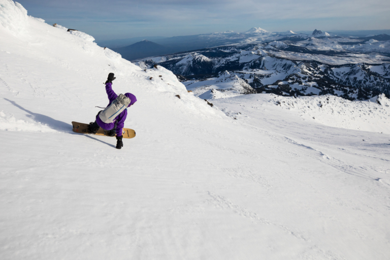
Shearer leans into late-day corn, reaping the rewards of a long ascent by laying one of the only tracks for miles around.
Awakening after our summit bid, the stillness of the night gave way to brisk east winds. A wall of thick clouds hung on the southern ridge we had traveled just hours prior. We broke camp quickly and began our descent back from where we’d come.
The sun warmed the snow into smooth corn. Each turn through the burnt timbers came with increasing speed, giving way to gravity. When we paused at the bottom to put skins back on for the slog out, the tops of young pines poked through the snow.
Just a year after the Lionshead Fire, wildflowers and brush have begun to grow from the ashes. Small maple and other hardwood saplings are now waist high. “Burned areas don’t stay black for long,” Casey says about the impacts of fire. “It’s still a forest. It’s still a living landscape. You can still go recreate.”
Fire can lead to renewal. It’s time we used fire to our advantage, rather than suppressing it until it burns out of control.
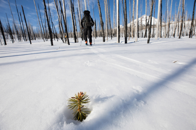
Rebirth. Necefer tours past a subtle sign of natural resilience and into the destruction of the Lionshead Fire.
Author Profile